Industrial Economics, Incorporated

  • About
    • AboutIEc sign
    • Our Story
    • Consulting Approach
    • Our Culture
    • Sustainability At IEc
  • Our Work
    • Natural Resource Management
    • Natural Resource Damage Assessment (NRDA)
    • Site Restoration & Remediation
    • Applied Sciences
    • Endangered Species
    • Water Resources Management
    • Public Policy AnalysisZakim bridge
    • NEPA Compliance
    • Regulatory Analysis & Support
    • Climate Change
    • Risk Analysis & Risk Communication
    • Energy
    • Applied EconomicsApplied Economics
    • Natural Resource Economics
    • Health Measurement & Valuation
    • Benefit-Cost Analysis
    • Utility Rate Regulation
    • Finance & Forensic AnalysisFinancial Management & Accounting
    • Penalty Assessments
    • Financial Analysis
    • Financial Management, Accounting, & Reporting
    • Economic & Financial Damages
    • Program Design & EvaluationProgram Design, Implementation, & Evaluation
    • Strategic Planning & Program Design
    • Measurement & Evaluation
    • Reporting & Communications
    • Sustainabilitywind turbine
    • Footprinting: Energy/Carbon, Water, Waste
    • Strategic Planning and Target Setting for a Low-Carbon Future
    • Sustainability Program Implementation Support
    • Environmental Reporting and Communications
    • Information Technologies & CommunicationInformation Technologies & Communication
    • Data Management
    • Decision Support Tools
    • Spatial Analysis / GIS
    • Graphic Design
    • Survey Research
  • Staff
    • StaffStaff
    • Our People
    • Senior Staff Profiles
    • Consulting Staff
    • Administrative Staff
  • Careers
    • CareersCareers
    • Open Positions
    • Career Development
  • Contracts
    • ContractsContracts
    • GSA Services
    • Procuring Work From IEc
  • Find Us
    • Find UsContact
    • Our Office
    • Our Neighborhood
    • California Privacy Rights

Mere nuisance or growing threat? The physical and economic impact of high tide flooding on US road networks

Charles Fant (a)*, Jennifer M. Jacobs (b), Paul Chinowsky (c), William Sweet (d), Natalie Weiss (e), Jo E. Sias (f), Jeremy Martinich (g), and James E. Neumann (h)

a. Senior Technical Consultant, Industrial Economics, Inc., 2067 Massachusetts Ave, Cambridge, MA 02140, cfant@indecon.com

b. Professor, Department of Civil and Environmental Engineering, University of New Hampshire, 453 Morse Hall, Durham, NH 03824, Jennifer.Jacobs@unh.edu

c. President, Resilient Analytics, Inc. and Professor, University of Colorado, 314 UCB, Boulder, CO 80309, pchinowsky@resilient-analytics.com

d. National Oceanic and Atmospheric Administration, National Ocean Service, Center for Operational Oceanographic Products and Services, Silver Spring, MD, USA, william.sweet@noaa.gov

e. Senior Research Analyst, Industrial Economics, Inc., 2067 Massachusetts Ave, Cambridge, MA 02140, weiss.natalie17@gmail.com

b. Professor, Department of Civil and Environmental Engineering, University of New Hampshire, 33 Academic Way, Kingsbury Hall, W183, Durham, NH 03824, Jo.Sias@unh.edu

g. Climate Scientist, U.S. Environmental Protection Agency, 1200 Pennsylvania Ave, NW MC6207A, Washington, D.C. 20460, USA, Martinich.Jeremy@epa.gov

h. Principal, Industrial Economics, Inc., 2067 Massachusetts Ave, Cambridge, MA 02140, JNeumann@indecon.com

* Corresponding author

Abstract

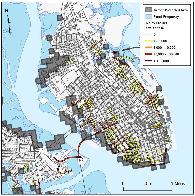
High Tide Flooding (HTF) already affects traffic in coastal areas across the United States but the issue will worsen significantly. This study advances the understanding of the risks and impacts of HTF on traffic by presenting national-scale risks in the form of traffic delays and indirect costs. By 2020, annual national-level costs are $1.3 and $1.5 billion but costs increase to $28 and $37 billion in 2050 and $220 and $260 billion in 2100 for RCP 4.5 and RCP 8.5, respectively. Total costs over the century are $1.0 trillion for RCP 4.5 and $1.3 trillion for RCP 8.5 (discounted 3%). By simulating a least-cost decision, additional protection of these roads by building sea walls or raising the road surface could significantly reduce these costs, bringing total discounted costs to $61 and $78 billion for RCP 4.5 and 8.5, respectively, but there remain many barriers in coastal areas to adopting least-cost adaptation decisions, meaning these gains may not be realized without both careful planning and information sharing.

Download the .zip data file

Map of Charleston, SC
Map of downtown Charleston, SC, where the roads with yellow, orange, red, and dark red are places where high tide flooding events will repeatedly (many times a year) cause road flooding and closures by 2050. The colors mark roads with 1-5k (yellow), 5-10k (orange), 10-100k (red), and over 100k (dark red) vehicle-hours of delay per year and include the effect of both official or driver-initiated rerouting to avoid these flooded roads. Grey boxes show places where sea walls are likely to be built to protect valuable property, and as a result reduce these traffic delays if they are designed properly.
Industrial Economics, Inc. Logo

2067 Massachusetts Ave, Cambridge, MA 02140 617.354.0074

© 2025 Industrial Economics, Incorporated